
Physical infrastructure has come a long way from the first cobblestone-lined streets to Saudi Arabia’s ambitious Neom project.
Now, as the next evolutionary step, blockchain technology along with something called Decentralized Physical Infrastructure (DePIN) are changing how our infrastructure is built and maintained, including maps.
The Lost Ages: Before Digital Mapping
Sometime in the second century A.D. Claudius Ptolemy invented geography as we know it.
Ptolemy accomplished this by gathering documents detailing the locations of nearby towns, which he primarily sourced from the tales of travelers.
It was said that by the time he grew old, he had devised a system of lines of latitude and longitude, and plotted some 10,000 locations, from Europe to Asia and Africa.
Following this initial guesswork, things began to get a little more precise, but not by much.
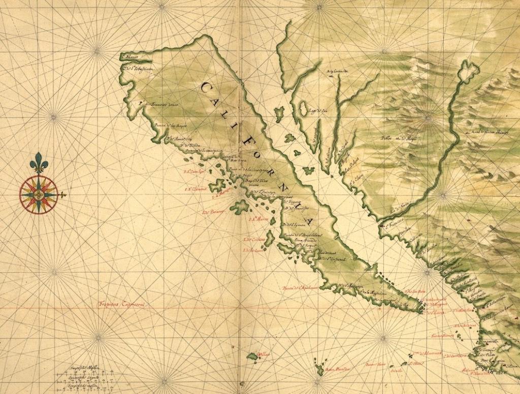
California continued to be drawn as an island well into the 18th Century and mapmakers misnaming streets to keep competitors from copying their work was all too common.
Fortunately, none of us were around for this early chaos, but if you’re reading this and over the age of 30, you will remember the “technology” that changed everything – the compass.
An Act of Visual Persuasion
Crude, but effective.
This is an accurate description of the magnetized needle compasses used to navigate land and sea.
These got people moving in the right direction, for a change, and set the stage for technology to take precedent in mapping.
Not Getting Lost Anymore
In 1996 the first web mapping service was launched.
MapQuest took us from fumbling around with foldable maps, hoping the landmarks were still relevant since the last time the map was printed to fumbling around with sheets of directions to our destination, accuracy almost assured.
Looking back, it’s a wonder anyone managed to get anywhere, let alone on time, but early services like MapQuest showed us what mapping could be.
Not just a way to not get lost anymore, but a way to interact with friends, find local amenities, and even see what others are saying about places we want visit.
Up until recently, Google Maps was probably the best representation of mapping’s potential.
Not only does it offer multiple interactive views, like satellite and street view, but also plenty of route planning options and local search engine optimization for businesses.
Still, it is not without its flaws.
First, apart from limited live traffic, no real-time data is available.
Things are always changing in the real world, weather conditions, accidents, events, etc. However, Google Maps has no way of capturing and disseminating this information in real-time.
Second, although anyone can sign up to become a Local Guide and contribute to Google Maps data, the benefits for doing so are severely limited.
Early access to Google features and undisclosed partner rewards are all it will get you.
According to an unanimous former Google Maps employee, some user submissions are ruled upon by people with little to no local knowledge of a place, such as offshore foreign contractors.
So what’s the solution?
A crowdsourced, decentralized global map with monetary rewards.
Capitalizing off Decentralized Physical Infrastructure (DePIN) Maps
At it’s core, DePIN is all about incentivizing the building and maintenance of physical infrastructure.
The concept marries the power of community with the rewards of a centralized platform and its beginning to get significant traction.
Some prominent early examples include Helium, which is a network of distributed internet hotspots created by it’s users, who are rewarded with the network’s own crypto token.
As of this writing, the network reports nearly 1 million hotspots throughout the U.S. and growing by the day.
Filecoin is another DePIN project that had a $250 million initial coin offering (ICO) in 2017 and aims to create a decentralized cloud storage network using the blockchain.
But what does this have to do with mapping?
The World’s Freshest Map
In the early 2010s, Ariel Seidman pondered “how do you truly build a global map?”
He experienced first hand how Yahoo wasn’t able to do it as part of their search and maps team in the early 2000s and how Google was able to by investing billions of dollars into acquisitions, which provided them access to massive amounts of geographical data.
He thought there had to be a better way and after being introduced to Helium network co-founder Amir Haleem, he knew DePIN was it.
With this in mind, the idea for Hivemapper was first conceived in 2015.

Hivemapper’s model is simple and straightforward:
- Contributors collect imagery via forward or side-facing 4K dashcams
- These are then transformed into an up-to-date, high resolution, and relevant global map
- Contributors are rewarded for every input they make with the network’s own token called HONEY, which was launched in 2022.
This stands in contrast to Google and Apple’s centralized map approach and OpenStreetMap’s unpaid crowdsourced way.
There are various reasons why a map should be as close to real-time as possible.
For one, it aids in emergency response navigation. Displaying roads that may be closed and alternative routes to take.
It is also a crucial reference point for the growing number of autonomous vehicles on the road, providing them with the latest traffic regulations, pinpointing potential hazards, and road conditions.
So far, Hivemapper’s model is working better than expected.
As of the midway point of 2024, some 25,000 to 40,000 Hivemapper drivers have already mapped over 20% of the world and they’ve done it nearly four times faster than Google.

It still has a long way to go to create a complete world map, but the Cadenza-back DePIN project is off to a sustainable start.
Hivemapper is also using artificial intelligence to help build its maps from contributed driving data.
It does this by extracting high-quality location data from images, which is then reviewed by a community of human “AI trainers” to ensure accuracy.
All of this contributes towards Hivemapper’s ultimate goal of creating the world’s freshest map.
Overall, the potential use cases for DePIN or crowd-sourced providers offering real-world services are nearly endless, decentralized WiFi networks, distributed energy, and real-time maps are only scratching the surface.
When combined with blockchain’s administrative, remittance, and record-keeping capabilities, DePIN may be the key to creating truly sustainable economies.
If you found this article insightful, you may also like The Tokenization of Real World Assets: Bigger Than The Internet? Or Crypto For Everyone: How ETFs are Taking the Blockchain Mainstream
If you would like more information on our thesis surrounding DePIN or other transformative technologies, please email info@cadenza.vc

3 responses to “Charting New Territory: How DePIN is Changing The Physical World With Digital Technology”
[…] you enjoyed this article, you may also like Charting New Territory: How DePIN is Changing The Physical World With Digital Technology or Regulatory Bans, Decentralized Apps, And Telegram: Exploring the TON […]
LikeLike
[…] you found this article insightful, you may also like Charting New Territory: How DePIN is Changing The Physical World With Digital Technology or The Tokenization of Real World Assets – Bigger Than The […]
LikeLike
[…] If you found this insightful, you will also like Raising the Bar: How AI is Transforming the Legal Practice and Charting New Territory: How DePIN is Changing The Physical World With Digital Technology […]
LikeLike